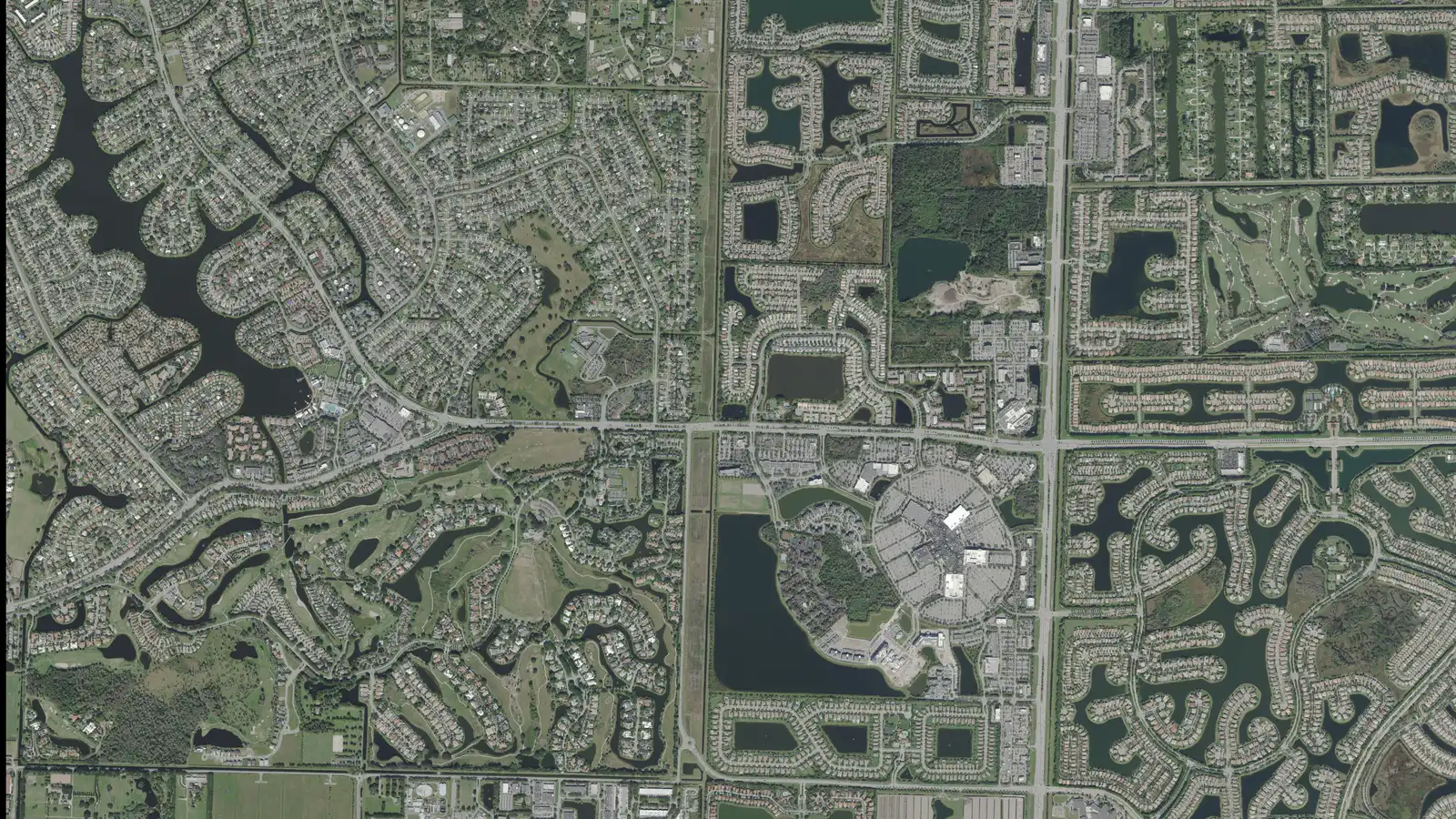
Wellington's 24,600 homes in 10 areas from the Village's own maps, with ZIP codes, zoned high schools, Zillow home values and the main roads.
Last checked Oct. 10, 2026. Sources: the Village of Wellington’s GIS neighborhood, planning, boundary and address layers and its Equestrian Preserve and Wellington Green and State Road 7 pages, Palm Beach County’s school zone open data, the Florida Department of Education’s 2026 school grades, the Zillow Home Value Index (Zillow Research), the U.S. Census Bureau and © OpenStreetMap contributors.
Wellington had 62,146 residents in the Census Bureau’s 2020-2024 American Community Survey (QuickFacts). The village covers about 46 square miles on its own boundary map, west of State Road 7 in central Palm Beach County, and its address layer lists about 24,600 residential addresses: 69% single-family houses and 31% apartments, condos and townhouses.
Most of the village grew from the Wellington Planned Unit Development, which the village still draws on its map: the older neighborhoods around Forest Hill Boulevard, Wellington Trace, Big Blue Trace and Greenview Shores Boulevard, with Village Hall and the Town Center beside Lake Wellington. To the east, along State Road 7 (U.S. 441), are the Mall at Wellington Green and newer gated communities. To the south and west is the Equestrian Preserve Area, the village’s horse country. Southern Boulevard runs along the northern edge to Florida’s Turnpike (exit 97) and the airport, and Lake Worth Road crosses the south to the Turnpike’s exit 93. There is no interstate exit inside the village.
On the village’s address layer, 90% of homes are in ZIP code 33414 and 6.5% in 33449; a few hundred in the northeast use 33411, a West Palm Beach ZIP code. School zones are a separate map: about 66% of homes are zoned for Wellington High and 34% for Palm Beach Central High, according to Palm Beach County’s copy of the district’s zones, and the line between them does not follow Forest Hill Boulevard or any ZIP code.
What this means for you
- Check that an address is inside the village before counting on village services; a Wellington mailing address can be in unincorporated Palm Beach County. The Property Appraiser’s parcel search shows the city for each parcel.
- The high school comes from the district’s zone for the address, not the ZIP code. Use the Find My School map.
- ZIP home values below are Zillow’s modeled typical values for August 2026, not sale prices.
The areas at a glance
| Area | Homes | Main ZIP | Zoned high school | Typical home value in that ZIP, Aug. 2026 |
|---|---|---|---|---|
| Binks Forest and the Landings | 1,800 | 33414 | Wellington | $624,058 |
| Big Blue Trace | 3,200 | 33414 | Wellington | $624,058 |
| Greenview Shores | 4,600 | 33414 | Wellington | $624,058 |
| MidTowne | 1,900 | 33414 | Wellington | $624,058 |
| North of Forest Hill Boulevard | 4,200 | 33414 | Palm Beach Central (59%), Wellington | $624,058 |
| Palm Beach Polo | 1,600 | 33414 | Wellington | $624,058 |
| Wellington Green | 2,400 | 33414 | Palm Beach Central (80%), Wellington | $624,058 |
| Olympia | 1,800 | 33414 | Palm Beach Central | $624,058 |
| Lake Worth Road | 2,100 | 33449 | Palm Beach Central | $741,047 |
| Equestrian Preserve | 1,000 | 33414 | Wellington | $624,058 |
Homes are residential addresses on the village’s address layer, rounded to the nearest hundred. Wellington High and Palm Beach Central High both earned an A in Florida’s 2026 school grades. Zillow’s figure for the whole village was $658,628, up 1.7% on the year; 33414 was up 1.6% and 33449 down 1.0%. The index covers each whole ZIP code, single-family homes and condos together. See our home prices guide for the village’s trend and our schools guide for every school.
Map of the areas
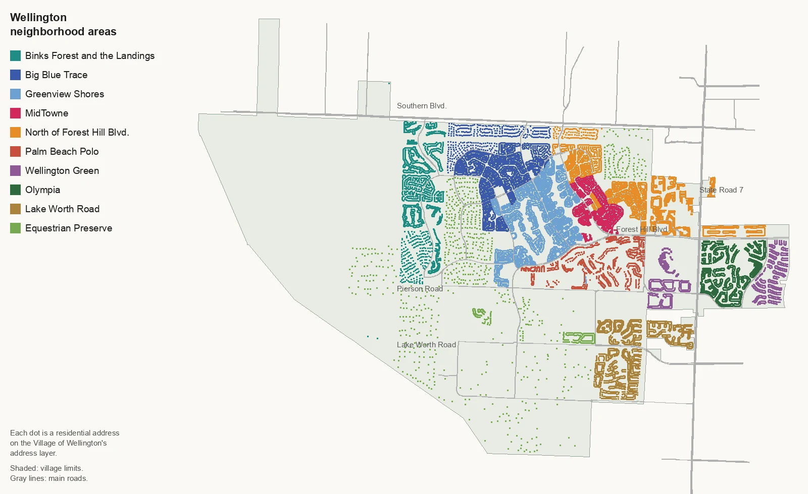
Map by Wellington Live from the Village of Wellington’s address and boundary layers; roads © OpenStreetMap contributors.
The west
Binks Forest and the Landings, west of the original PUD, have about 1,800 homes, nearly all single-family houses, with Greenbriar Park and the Wellington Dog Park.
The original village
Big Blue Trace takes in Sugar Pond Manor, Paddock Park and the Pinewood neighborhoods between Southern Boulevard and Wellington Trace.
Greenview Shores, the largest area, about 4,600 homes, runs south of Wellington Trace around Tiger Shark Cove and nine village neighborhood parks.
MidTowne is the village’s own name for the district around Village Hall, the Town Center and Lake Wellington; two in three of its homes are multifamily.
North of Forest Hill Boulevard covers Eastwood, Wellington’s Edge, Black Diamond and Buena Vida out to State Road 7, and has more school zone splits than any other area.
The east
Palm Beach Polo, south of Forest Hill Boulevard, is a gated community of about 1,600 homes across Pierson Road from Village Park.
Wellington Green surrounds the Mall at Wellington Green, the hub for four Palm Tran routes, with Villagewalk and The Estates at Wellington Green.
Olympia, east of State Road 7, has about 1,800 single-family homes next to Olympia Park.
Lake Worth Road groups Grand Isles, the Isles of Wellington, Versailles and Wellington Shores, most of them in ZIP code 33449.
Horse country
The Equestrian Preserve covers most of southern and western Wellington, with about 1,000 homes, many on ranch lots, plus the polo clubs, show grounds and the Wellington Environmental Preserve.
Related guides
Property taxes, parks and trails, getting around, moving to Wellington and Wellington vs. Royal Palm Beach, Westlake and Greenacres.
How we built this
The areas come from the Village of Wellington’s own GIS layers, published on its map server: the neighborhood layer, which names about 210 residential neighborhoods and classes eight of them (among them Olympia, Palm Beach Polo and Bink’s Forest) as “main subdivisions”; the planning layers, which draw the MidTowne district, the Wellington PUD, the Equestrian Preserve Area and the sub-areas of the Equestrian Overlay Zoning District; and the address layer, which gives each address a neighborhood, a ZIP code and a type. Where the village names a district or main subdivision, the page follows that boundary. The rest of the village’s named neighborhoods we grouped, whole, by the main roads between them (Forest Hill Boulevard, Wellington Trace, State Road 7 and Lake Worth Road) and named each group for a road or for its position; those pages say so.
OpenStreetMap lists a few place names inside the village, among them Wellington’s Edge, Polo Lakes and Lakefield West, which match the village’s own neighborhood names and are mentioned on the pages they fall in. Every residential address was matched on Oct. 10, 2026, to the village’s layers and to Palm Beach County’s open data copy of the district’s attendance zones. The ZIP code list is the Census Bureau’s 2020 ZIP code relationship file and the village’s address layer.
Frequently asked questions
What are the neighborhoods of Wellington, Florida?
The Village of Wellington’s neighborhood layer names about 210 neighborhoods. Our guide groups them into 10 areas: Binks Forest and the Landings, Big Blue Trace, Greenview Shores, MidTowne, north of Forest Hill Boulevard, Palm Beach Polo, Wellington Green, Olympia, Lake Worth Road and the Equestrian Preserve.
What ZIP codes are in Wellington, Florida?
Mainly 33414, with 90% of the village’s residential addresses, and 33449, with 6.5%, on the village’s address layer. A few hundred addresses in the northeast use 33411, and a few dozen in the far west use 33470.
What high schools serve Wellington?
Wellington High and Palm Beach Central High. About 66% of the village’s homes are zoned for Wellington High and 34% for Palm Beach Central in Palm Beach County’s copy of the district’s zones; both earned an A in Florida’s 2026 school grades.
Which Wellington ZIP code has the higher home values?
33449, at $741,047 in August 2026, according to the Zillow Home Value Index. The figure for 33414 was $624,058, and for Wellington as a whole $658,628.
Have your say